เป็นเวลากว่า 500 ปีแล้ว ที่โลกพึ่งพาแผนที่ที่บิดเบือน
แผนที่เมอร์เคเตอร์ทำให้ขนาดที่แท้จริงของทวีป ต่างๆ บิดเบือนไปอย่างมาก แผนที่นี้ ขยายพื้นที่ใกล้ขั้วโลก และทำให้พื้นที่ใกล้เส้นศูนย์สูตรเล็กลง ทำให้สถานที่ต่างๆ เช่น ยุโรป อเมริกาเหนือ และกรีนแลนด์ ดูใหญ่กว่าความเป็นจริงมาก ในขณะที่แอฟริกา อเมริกาใต้ และเอเชียตะวันออกเฉียงใต้กลับดูเล็กลง ...
คุณคิดว่า กรีนแลนด์ ใหญ่กว่าแอฟริกาหรือไม่ ? ....
คำตอบ คือ ..... มันไม่ใกล้เคียงเลย กรีนแลนด์ มีพื้นที่ประมาณ 836,000 ตารางไมล์ ในขณะที่ แอฟริกามีพื้นที่มากกว่า 11.7 ล้านตารางไมล์ ซึ่งใหญ่กว่าถึง 14 เท่า ...!!!
สหรัฐอเมริกา และยุโรป ดูใหญ่โตมาก บนแผนที่ เมอร์เคเตอร์ ( Mercator ) แต่ในความเป็นจริงแล้ว ขนาดของ แอฟริกา สามารถรวม สหรัฐอเมริกา จีน อินเดีย และยุโรปส่วนใหญ่ไว้ด้วยกันได้ ....โดยยังมีพื้นที่เหลืออีกมาก !!!
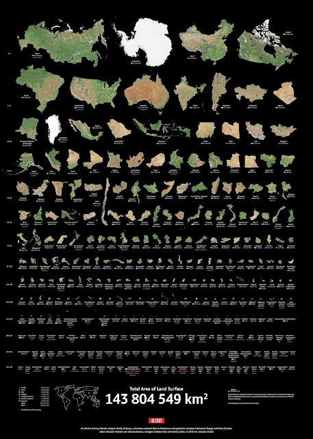
แผนที่พื้นที่จริงนี้ แสดงให้เห็นภาพทวีปต่างๆ ที่ปรับขนาดตามพื้นที่ดินจริง แผนที่ไม่ได้สะท้อนถึงขอบเขตทางการเมือง แต่มันส่งสาร ที่ทรงพลัง
แผนที่ของเรากำหนดวิธีที่เราเห็นโลก ไม่ว่าจะเป็นทางภูมิศาสตร์ วัฒนธรรม หรือแม้กระทั่งการเมือง
แผนที่ไม่ใช่แค่เครื่องมือเท่านั้น แต่ยังเป็นเรื่องเล่าด้วย และเมื่อแผนที่ย่อขนาดทวีปทั้งทวีปและขยายขนาดทวีปอื่นๆ แผนที่ก็จะเสริมสร้างมุมมองโลกที่ล้าสมัยอย่างแนบเนียน ...
การมองแอฟริกา อเมริกาใต้ และเอเชียตะวันออกเฉียงใต้ในสัดส่วนที่แท้จริงนั้นไม่ใช่แค่บทเรียนภูมิศาสตร์เท่านั้น แต่ยังเป็นการเตือนให้เราตั้งคำถามกับสิ่งที่เราได้เห็น ... ?
This map will change how you see the world.
For over 500 years, the world has relied on a distorted map.
The Mercator projection dramatically distorts the true size of continents. It stretches land near the poles and shrinks areas near the equator, making places like Europe, North America, and Greenland look much larger than they are, while Africa, South America, and Southeast Asia are minimized.
Think Greenland is bigger than Africa? It’s not even close. Greenland is about 836,000 square miles, while Africa is over 11.7 million. That’s 14 times larger.
The U.S. and Europe look huge on the Mercator map, but in reality, Africa could fit the U.S., China, India, and most of Europe inside it – with room to spare.
This true area map sets the record straight, showing continents resized based on their actual land area. It doesn’t reflect political borders, but it sends a powerful message: our maps shape how we see the world – geographically, culturally, and even politically.
Maps aren’t just tools; they’re narratives. And when a map minimizes whole continents and enlarges others, it subtly reinforces outdated worldviews.
Seeing Africa, South America, and Southeast Asia in their true proportions is more than just a geography lesson; it’s a reminder to question what we’ve been shown.
To see the full map
ข้อมูลโดย : The True Size of Land Masses - Full Size


